Property Details
Property Description
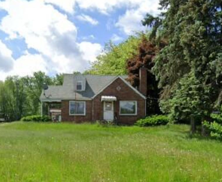
Subject Property is a 3 BR / 1.5 BA Single Family Home containing 1,160 Sq Ft +/- built in 1947. Minimum bid $ 86,000.00. All auctions end Wednesday's at 1pm. 5% buyers premium will apply over and above high bid. Please read terms and conditions for details related to purchasing foreclosure property. Interior showings are not available. Buyer agents must register with Auctioneer to earn commission at https://www.gryphonusa.com/broker-acknowledgement-form/ *** Information available has come from public sources and is believed to be accurate but is not guaranteed. Buyers should conduct their own due diligence before bidding. Auctioneer/PSO has not physically viewed the property.
Legal Description
Situated in the Township of Plain, County of Stark and State of Ohio: Known as being part of a 1.15 acre tract now owned by George & Manuela Johnson and described in Instrument Number 200204160030618 in the Stark County Recorders Office. Also known as part of the Northwest Quarter of Section 30 in Plain Township (T-11 R-8), Stark County, Ohio and being more fully described as follows: Beginning at a 5/8" bar found marking the southeast corner of said northwest quarter section (Stark County GIS point PLA-119, No GIS coordinates available). (1) Thence along the south line of the quarter section N 85? 12' 00" W, 2045.73' to a pin set on the southeast corner of a 1.14 acre tract now owned by John and Victoria Cannell as described in Instrument Number 199612110067609 and the southwest corner of the 1.15 acre parent tract passing through 5/8" bars found at 605.26', 1490.66', 1951.30' and a point set at 1965.45'. (2) Thence along the common line of said tracts N 04? 34' 42" E, 388.06' to a pin set and the true place of beginning of the tract herein described. (3) Thence continuing along said common line N 04? 34' 42" E, 235.25' to a mag nail set in the center of 38th Street NW (C-213) passing through a pin set at 220.19'. (4) Thence along said center N 89? 11' 49" E, 80.35' to a mag nail set on the northeast corner of the 1.15 acre parent tract and the northwest corner of a 6.519 acre tract now owned by First Baptist Church trustee's as described in Deed Volume 3788 : 330. (5) Thence along the common line of said tracts passing through a 1" bar found at 14.86' and a pin set at 30.00', S 04? 34' 42" W, 242.79' to a pin set. (6) Thence N 85? 25' 18" W, 80.00' to a pin set and the true place of beginning containing 0.439 acres more or less with 0.027 acres in the right of way of 38th Street leaving a remainder of 0.412 acres as surveyed by Bradley K. Harper P.S. # 7901 in January, 2007. Bearings based on the south line of the quarter section (N 85? 12' 00" W) as per I.N. 200204160030618. All iron pins set are 30" x 5/8" rebar with "HARPER 7901" caps unless otherwise noted. Reference documents include: I.N. 200204160030618, I.N. 20005080026552, I.N. 200212020098317, I.N. 1997060900313314, I.N. 199907210056292, I.N. 198210290021786, I.N. 200401160003285 Cooper survey, Hammontree survey and Tax Map. This legal description prepared from a Boundary survey done by me conforms to chapter 4733-37 of the Ohio Administrative code.
Location
Foreclosure Details
Click the link to review the Conditions of Sale for this auction.
Conditions of SaleAuction By
